
Description
StellaSpark Nexus is a real-time digital twin platform for monitoring and simulating the natural and built environment across sectors such as urban planning, public safety, construction, water management, energy, mobility, telecommunications, forestry, and environmental management. It is used by governments, NGOs, utilities, contractors, engineers, and technical consultants to unify live data, run operational analysis, and share insights across organizations and public stakeholders.
Nexus excels at the following tasks:
- Integrate - Collect and transform information from virtually any data source in real time. Visualize unified geospatial data and timeseries in a high performance web viewer built for large, complex environments.
- Calculate - Deploy pre-built scripts, physics-based models or machine learning algorithms to generate performance metrics, statistics and predictions from incoming data streams.
- Share - Distribute data in various formats to partner organization or third-party applications through a web API or database connection, and publish selected views as public open data portals when needed.
Link map features with timeseries and photos
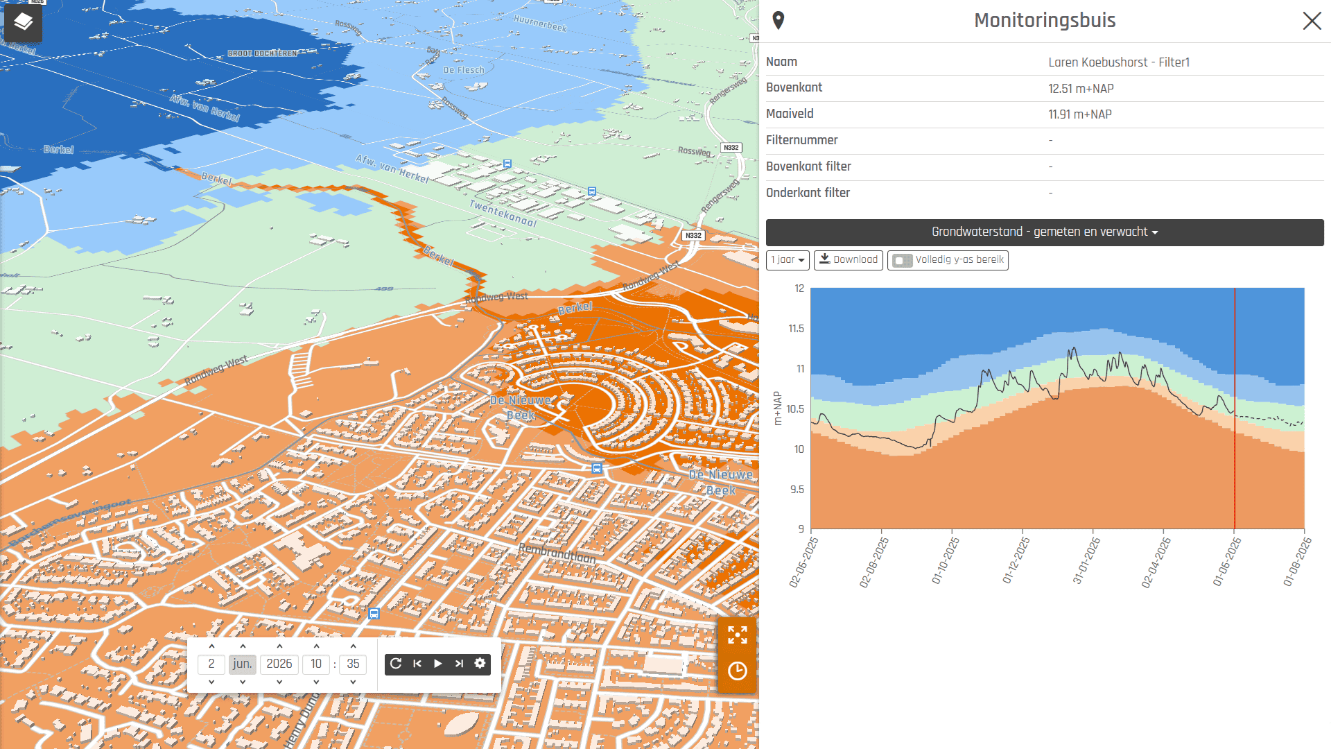
Select any feature on the map to view its live sensor data, historical trends, associated properties or photos. This cuts investigation time from hours to minutes.
Visualize in 2D or 3D
Bring raster and vector data to life in 2D or 3D maps. Apply rule-based or data-driven coloring to map features to highlight locations with anomalies. Time travel to inspect historical states or modeled future scenarios.
Explore time series with interactive charts
Connect sensor measurements to spatial objects or regions and display results in interactive charts. Visualize thresholds to detect exceedances of safety, compliance, or operational limits. Chart configuration supports custom indicators, aggregation methods, and domain-specific layouts.
Connect anything
Integrate data from virtually any spatial format and protocol (KML, GML, GeoJSON, Geotiff, WMTS, WFS, HDF, NetCDF, Shapefile), photos, time series from IoT devices and sensors such as JSON, CSV, XML or semi-structured data from websites. Use one of the 200+ data sources already available in Nexus or bring your own.
Always up-to-date
Keep data at its original source and let Nexus connect to it to bring it to life. Maps and charts update continuously, ensuring the digital twin reflects the current state of assets and environments without requiring manual re-imports or refreshes.
Operational forecasting and scenario analysis
Get decision support by simulating based on live data rather than static model inputs. Deploy built-in or user-supplied calculations, such as scripts in any programming language, trained machine learning algorithms, or physics-based models. Supported use cases include:
- Scenario modeling (“what-if” studies)
- Policy and performance indicator generation
- Compliance and safety limit evaluation
- Spatial interpolation
- Continous operational forecasting
Open ecosystem
Nexus comes pre-packed with more than 20 simulation models, but can be extended by anyone with additional calculations. Users can choose to let Nexus handle data synchronisation and visualization, but can also plug their own frontend visualization on top of Nexus.
Work from anywhere on any device
Access the digital twin in the field or in the office. The browser-based viewer runs on desktop, tablet, and mobile without additional software installation.
Share data with partners and citizens
Use Nexus as an open data portal, or securily connect Nexus to external applications through REST APIs or direct database connections for programmatic access. Supported ecosystem integrations include GIS platforms (ArcGIS Online, QGIS), BI and analytics tools (Tableau, Power BI), and Python workflows for custom processing and automation.
Target audience
Owner of the product
Sign in to access this information.Software data
|
|
| Commercial |